
Not Finding Your Answer?
Post It On KidzTalk Homework Help
Post It On KidzTalk Homework Help
Report a search problem

|
mobile version
Copyright 2005-2024 KidzSearch.com
|
|
 | |
 Coat of Arms of the Borough Council | |
 Trafford shown within England | |
| Coordinates: Coordinates: 53°26′46″N 2°18′29″W / 53.44611°N 2.30806°W / 53.44611; -2.30806 | |
| Sovereign state | United Kingdom |
| Constituent country | England |
| Region | North West England |
| Ceremonial county | Greater Manchester |
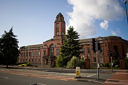
| Admin HQ | Stretford |
| Founded | 1 April 1974 |
| Government | |
| • Type | Metropolitan borough |
| • Governing body | Trafford Metropolitan Borough Council |
| • Mayor | Cllr. Stephen Adshead |
| • MPs: | Graham Brady (C) Paul Goggins (L) Beverley Hughes (L) |
| Area | |
| • Total | 40.94 sq mi (106.04 km2) |
| Elevation | 100 ft (30 m) |
| Population (2005 est.) | |
| • Total | 213,200 (Ranked 62nd) |
| • Density | 5,170/sq mi (1,997/km2) |
| • Ethnicity (2005 Estimate) | 89.7% White 5.1% S. Asian 2.3% Black 1.8% Mixed 1.1% Chinese and other |
| Time zone | UTC+0 (Greenwich Mean Time) |
| Postcode | |
| ISO 3166-2 | GB-TRF |
| ONS code | 00BU |
| NUTS 3 | UKD31 |
| Website | www.trafford.gov.uk |
The Metropolitan Borough of Trafford is a metropolitan borough of Greater Manchester, England. It is home to 211,800 people, covers 41 square miles, and includes the towns of Altrincham, Partington, Sale, Stretford, and Urmston. Until 1974 the area was part of Cheshire. view more...