
Not Finding Your Answer?
Post It On KidzTalk Homework Help
Post It On KidzTalk Homework Help
Report a search problem

|
mobile version
Copyright 2005-2024 KidzSearch.com
|
|
 Flag  Coat of arms | |
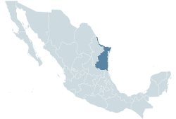 Location within Mexico | |
| Coordinates: 24°17′14″N 98°33′48″W / 24.2872°N 98.5633°W / 24.2872; -98.5633Coordinates: 24°17′14″N 98°33′48″W / 24.2872°N 98.5633°W / 24.2872; -98.5633 | |
| Country | Mexico |
| Capital | Victoria |
| Municipalities | 43 |
| Largest City | Tampico |
| Government | |
| • Governor | Eugenio Hernández Flores (PRI) |
| • Federal Deputies | PAN:5 PRI:3 |
| • Federal Senators | PAN:2 PRI:1 |
| Area | |
| • Total | 79,384 km2 (30,650 sq mi) |
| Population (2005) | |
| • Total | 3,024,238 (Ranked 13th) |
| • Demonym | Tamaulipeco |
| Time zone | UTC-6 (CST) |
| • Summer (DST) | UTC-5 (CDT) |
| HDI (2004) | 0.8111 - high Ranked 11th |
| ISO 3166-2 | MX-TAM |
| Postal abbr. | Tamps. |
| Website | Tamaulipas state government |
Tamaulipas is a state in the northeast of Mexico. About 3,025,000 people live there. Its capital is called Ciudad Victoria.
| States | Aguascalientes • Baja California • Baja California Sur • Campeche • Chiapas • Chihuahua • Coahuila • Colima • Durango • Guanajuato • Guerrero • Hidalgo • Jalisco • Mexico • Michoacán • Morelos • Nayarit • Nuevo León • Oaxaca • Puebla • Querétaro • Quintana Roo • San Luis Potosí • Sinaloa • Sonora • Tabasco • Tamaulipas • Tlaxcala • Veracruz • Yucatán • Zacatecas |
|---|---|
| National capital | |