
Not Finding Your Answer?
Post It On KidzTalk Homework Help
Post It On KidzTalk Homework Help
Report a search problem

|
mobile version
Copyright 2005-2024 KidzSearch.com
|
|
City | |
 | |
| Coordinates: 8°50′18″S 13°14′4″E / 8.83833°S 13.23444°E / -8.83833; 13.23444 | |
| Country | |
| Province | Luanda |
| Founded | 1576 |
| Area | |
| • City | 116 km2 (45 sq mi) |
| • Metro | 1,876 km2 (724 sq mi) |
| Elevation | 6 m (20 ft) |
| Population | |
| • City | 2,571,861 |
| • Metro | 8,069,612 |
| • Metro density | 4,301.5/km2 (11,140.8/sq mi) |
| 2019 | |
| Time zone | +1 |
| Climate | BSh |
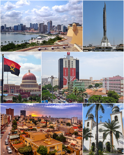
Luanda is the capital and the largest city of Angola. Its former name was Loanda. It is a main seaport of the country on the Atlantic Ocean. In 1995, about 3 million people lived there.
It is a center of manufacturing, but very destroyed because of a long civil war.
It was founded by Portuguese in 1575 as São Paulo de Luanda and has been the administrative center of Angola since 1627 (except for 1640–1648). When Angola got independence in 1975, it became the capital of Angola. view more...