Not Finding Your Answer?
Post It On KidzTalk Homework Help
Post It On KidzTalk Homework Help
Report a search problem

|
mobile version
Copyright 2005-2024 KidzSearch.com
|
|
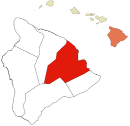
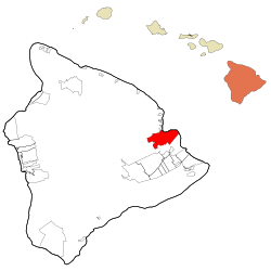 Location in Hawaii County and the state of Hawaii | |
| Coordinates: 19°42′20″N 155°5′9″W / 19.70556°N 155.08583°W / 19.70556; -155.08583Coordinates: 19°42′20″N 155°5′9″W / 19.70556°N 155.08583°W / 19.70556; -155.08583 | |
| Country | United States |
| State | Hawaii |
| County | Hawaii |
| Area | |
| • Total | 58.3 sq mi (151.0 km2) |
| • Land | 53.4 sq mi (138.3 km2) |
| • Water | 4.9 sq mi (12.7 km2) |
| Elevation | 59 ft (18 m) |
| Population (2020) | |
| • Total | 44,186 |
| • Density | 757.9/sq mi (292.62/km2) |
| Time zone | UTC-10 (Hawaii-Aleutian) |
| ZIP codes | 96720-96721 |
| FIPS code | 15-14650 |
| GNIS feature ID | 0359187 |
Hilo (pronounced /ˈhiːloʊ/) is the second-largest CDP in the State of Hawaiʻi and the largest settlement on the island of Hawaiʻi with a population of 44,186 during the 2020 census.
Hilo is the county seat of Hawaiʻi County, Hawaiʻi, and is in the South Hilo District. The town overlooks Hilo Bay.
Hilo is near two shield volcanoes
Some of the best ground-based astronomical observatories are on Mauna Kea.