Not Finding Your Answer?
Post It On KidzTalk Homework Help
Post It On KidzTalk Homework Help
Report a search problem

|
mobile version
Copyright 2005-2024 KidzSearch.com
|
|
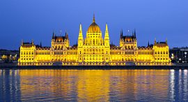
| Capital City of Hungary Magyarország fővárosa | |||||||
| |||||||
 Flag  Coat of arms | |||||||
| Coordinates: 47°29′33″N 19°03′05″E / 47.49250°N 19.05139°E / 47.49250; 19.05139Coordinates: 47°29′33″N 19°03′05″E / 47.49250°N 19.05139°E / 47.49250; 19.05139 | |||||||
| Country | Hungary | ||||||
| Region | Central Hungary | ||||||
| Unification of Buda, Pest and Óbuda | 17 November 1873 | ||||||
| Government | |||||||
| • Type | Mayor – Council | ||||||
| • Body | General Assembly of Budapest | ||||||
| • Mayor | Gergely Karácsony (Dialogue) | ||||||
| Area | |||||||
| • Capital city | 525.2 km2 (202.8 sq mi) | ||||||
| • Urban | 2,538 km2 (980 sq mi) | ||||||
| • Metro | 7,626 km2 (2,944 sq mi) | ||||||
| Elevation | Lowest (Danube) 96 m Highest (János Hill) 527 m (315 to 1,729 ft) | ||||||
| Population | |||||||
| • Capital city | 1,752,286 | ||||||
| • Rank | 1st (9th in EU) | ||||||
| • Density | 3,388/km2 (8,770/sq mi) | ||||||
| • Urban | 2,997,958 | ||||||
| • Metro | 3,011,598 | ||||||
| Time zone | UTC+1 (CET) | ||||||
| • Summer (DST) | UTC+2 (CEST) | ||||||
| Postal code(s) | 1011–1239 | ||||||
| ISO 3166 code | HU-BU | ||||||
| NUTS code | HU101 | ||||||
| HDI (2018) | 0.901 – very high · 1st | ||||||
| Website | BudapestInfo Official Government Official | ||||||
| Page Template:Infobox/extras.css has no content. | |||||||
| Official name | Budapest, including the Banks of the Danube, the Buda Castle Quarter and Andrássy Avenue | ||||||
| Criteria | Cultural: ii, iv | ||||||
| Reference | 400 | ||||||
| Inscription | 1987 (11th Session) | ||||||
| Extensions | 2002 | ||||||
| Area | 473.3 ha | ||||||
| Buffer zone | 493.8 ha | ||||||
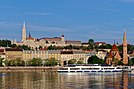
Budapest is the capital and largest city of Hungary. It was made as such in 1873. In that year, three towns on the River Danube, namely Buda, Óbuda (Old Buda) and Pest were united. About 1.7 million people live in the city. Its highest place is János Hill (527 m).