
Not Finding Your Answer?
Post It On KidzTalk Homework Help
Post It On KidzTalk Homework Help
Report a search problem

|
mobile version
Copyright 2005-2024 KidzSearch.com
|
|
City | |
 | |
 Seal | |
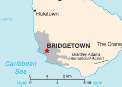 Location of Bridgetown (red star) | |
| Coordinates: 13°06′21″N 59°36′47″W / 13.10583°N 59.61306°W / 13.10583; -59.61306Coordinates: 13°06′21″N 59°36′47″W / 13.10583°N 59.61306°W / 13.10583; -59.61306 | |
| Country | Barbados |
| Parish | Saint Michael |
| Established | 1628 |
| Area | |
| • Total | 15 sq mi (40 km2) |
| Elevation | 3 ft (1 m) |
| Population (2006) | |
| • Total | 96,578 |
| • Density | 6,440/sq mi (2,490/km2) |
| Time zone | UTC-4 (Eastern Caribbean Time Zone) |
The city of Bridgetown is the capital and largest city of the nation of Barbados. It was called the Town of Saint Michael. It is in the parish of Saint Michael. Bridgetown is sometimes locally called "The City", but more common is simply "Town".
The Bridgetown port, found along Carlisle Bay, is on the southwestern coast of the island. The Grantley Adams International Airport for Barbados, is 16 kilometres (9.9 mi) southeast of Bridgetown city centre.