
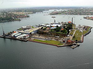
• cockatoo island new south wales

Not Finding Your Answer?
Post It On KidzTalk Homework Help
Post It On KidzTalk Homework Help
Report a search problem

|
mobile version
Copyright 2005-2024 KidzSearch.com
|
|
| UNESCO World Heritage Site | |
|---|---|
 | |
| Part of | Australian Convict Sites |
| Criteria | Cultural: iv, vi |
| Reference | 1306-010 |
| Inscription | 2010 (34th Session) |
| Cockatoo Island Sydney, New South Wales | |||||||||||||||
|---|---|---|---|---|---|---|---|---|---|---|---|---|---|---|---|
| Coordinates | 33°50′49″S 151°10′16″E / 33.84684°S 151.17115°ECoordinates: 33°50′49″S 151°10′16″E / 33.84684°S 151.17115°E | ||||||||||||||
| Population | 2 (2006) | ||||||||||||||
| • Density | 11.2/km2 (29/sq mi) | ||||||||||||||
| Area | 0.179 km2 (0.1 sq mi) | ||||||||||||||
| Location | 10 km (6 mi) west of CBD | ||||||||||||||
| LGA(s) | Inner West Council | ||||||||||||||
| State electorate(s) | Drummoyne | ||||||||||||||
| Federal division(s) | Sydney | ||||||||||||||
| |||||||||||||||
Cockatoo Island is the largest island in Sydney Harbour in Sydney, New South Wales, Australia. It is at the junction of the Parramatta and Lane Cove rivers. Cockatoo Island has been a prison, industrial school, and reformatory (a prison for boys). It was also the site of one of Australia's biggest shipyards during the 20th century. The first of its two dry docks was built by convicts in 1857. The dockyards closed in 1992.

