KidzSearch - Safe Search Engine     

   web | images | video | facts | wiki | news | games | kidztube | apps


   Related Content
    • border states in civil war
    • border states of california
    • border states of north carolina
    • border states of illinois
    • border states of arizona
    • border states of south dakota
    • border states in north carolina
    • border states of indiana
    • border states of missouri
    • border states of kentucky


Not Finding Your Answer?
Post It On KidzTalk Homework Help


   Report a search problem


COMPANY RESOURCES LINKS SOCIAL
contact us education daily journal home facebook
about us make us your default search kidztalk twitter  
terms/privacy blocking websites kidznet pinterest  
advertise teacher zone wiki    
media link to us learning sites    
business / api solutions add a site image search    
affiliate program kidzsearch apps kidztube    
play youtube on kidzsearch games    
  voice search music    
  report a problem cool facts    
  settings news    
    search help    


 mobile version

      Copyright 2005-2024 KidzSearch.com 
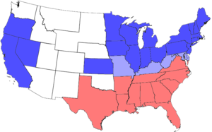
All blue areas represent Union states, including those admitted during the war; light blue areas represent Union states which permitted slavery; red areas represent Confederate states.

The Border states were those states that during the American Civil War did not leave the Union. The border states were Delaware, Maryland, Kentucky, and Missouri. After West Virginia separated from Virginia, it was also considered a border state. Most border states had strong ties to the South culturally, but they had economic ties to the North. While remaining loyal to the Union, the Border States were themselves slave-holding states.

 view more...


Maps, States & Borders

Maps, States & Borders
more videos...