|
|---|
|
| State of Vermont |
|
-
|
-
|
| Anthem: These Green Mountains |
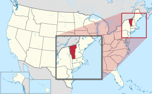 Map of the United States with Vermont highlighted |
| Country | United States |
|---|
| Before statehood | Vermont Republic |
|---|
| Admitted to the Union | March 4, 1791 (14th) |
|---|
| Capital | Montpelier |
|---|
| Largest city | Burlington |
|---|
| Largest metro | Greater Burlington |
|---|
|
| • Governor | Phil Scott (R) |
|---|
| • Lieutenant Governor | David Zuckerman (D) |
|---|
| Legislature | General Assembly |
|---|
| • Upper house | Senate
President pro tempore: Becca Balint (D) |
|---|
| • Lower house | House of Representatives
Speaker: Jill Krowinski (D) |
|---|
| U.S. senators | Patrick Leahy (D)
Bernie Sanders (I) |
|---|
| U.S. House delegation | Peter Welch (D) (list) |
|---|
|
| • Total | 9,616 sq mi (24,923 km2) |
|---|
| • Land | 9,250 sq mi (23,957.39 km2) |
|---|
| • Water | 382 sq mi (989 km2) 4.1% |
|---|
| • Rank | 45th |
|---|
| Elevation | 1,000 ft (300 m) |
|---|
| Highest elevation | 4,395 ft (1,340 m) |
|---|
| Lowest elevation | 95 to 100 ft (29 to 30 m) |
|---|
|
| • Total | 643,503 |
|---|
| • Rank | 49th |
|---|
| • Density | 67.7/sq mi (26.1/km2) |
|---|
| • Rank | 30th |
|---|
| • Median household income | $57,513 |
|---|
| • Income rank | 28th |
|---|
|
| Time zone | UTC−05:00 (Eastern) |
|---|
| • Summer (DST) | UTC−04:00 (EDT) |
|---|
| USPS abbreviation | VT |
|---|
| ISO 3166 code | US-VT |
|---|
| Trad. abbreviation | Vt. |
|---|
| Latitude | 42°44′ N to 45°1′ N |
|---|
| Longitude | 71°28′ W to 73°26′ W |
|---|
| Website | www.vermont.gov |
|---|
Vermont is a state in the United States. Its capital city is Montpelier, and its largest city is Burlington. It is one of the six New England states. About 640,000 people lived there in 2020.
The states that border Vermont are Massachusetts to the south, New Hampshire to the east, New York to the west, and the Canadian province of Quebec to the north.