

Not Finding Your Answer?
Post It On KidzTalk Homework Help
Post It On KidzTalk Homework Help
Report a search problem

|
mobile version
Copyright 2005-2024 KidzSearch.com
|
|
 | |
 Coat of arms | |
Location of Untersiggenthal Lua error in Module:Infobox_mapframe at line 118: attempt to index field 'wikibase' (a nil value). | |
| Coordinates: 47°30′N 8°15′E / 47.500°N 8.250°ECoordinates: 47°30′N 8°15′E / 47.500°N 8.250°E | |
| Country | Switzerland |
| Canton | Aargau |
| District | Baden |
| Area | |
| • Total | 8.36 km2 (3.23 sq mi) |
| Elevation | 375 m (1,230 ft) |
| Population (December 2005) | |
| • Total | 6,298 |
| • Density | 753.3/km2 (1,951.2/sq mi) |
| Time zone | UTC+01:00 (Central European Time) |
| • Summer (DST) | UTC+02:00 (Central European Summer Time) |
| Postal code(s) | 5417 |
| Surrounded by | Brugg, Gebenstorf, Obersiggenthal, Turgi, Villigen, Würenlingen |
| Website | www SFSO statistics |
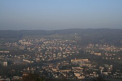
Untersiggenthal is a municipality of the district of Baden in the canton of Aargau in Switzerland. view more...