

Not Finding Your Answer?
Post It On KidzTalk Homework Help
Post It On KidzTalk Homework Help
Report a search problem

|
mobile version
Copyright 2005-2024 KidzSearch.com
|
|
 | |
 Coat of arms | |
Location of Pirmasens Lua error in Module:Infobox_mapframe at line 118: attempt to index field 'wikibase' (a nil value). | |
| Coordinates: 49°12′N 7°36′E / 49.200°N 7.600°ECoordinates: 49°12′N 7°36′E / 49.200°N 7.600°E | |
| Country | Germany |
| State | Rhineland-Palatinate |
| District | Urban district |
| Government | |
| • Lord mayor | Bernhard Matheis (CDU) |
| Area | |
| • Total | 61.37 km2 (23.70 sq mi) |
| Elevation | 380 m (1,250 ft) |
| Population (2006-12-31) | |
| • Total | 40,887 |
| • Density | 666.24/km2 (1,725.55/sq mi) |
| Time zone | UTC+01:00 (CET) |
| • Summer (DST) | UTC+02:00 (CEST) |
| Postal codes | 66953–66955 |
| Vehicle registration | PS |
| Website | www.pirmasens.de |
Pirmasens (Palatine German: Bärmesens) is an independent town in Rhineland-Palatinate, Germany. It is near the border with France and was the center of the shoe industry in Germany until around 1970.
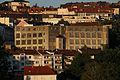
View with shoe factory

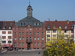
Shoe factory and city hall tower
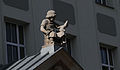
Shoemaker boy

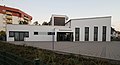
Dynamikum

Old post office
New Apostolic Church

Listed residential building

Listed villa

Stairway of the birds

Stairway of the birds