KidzSearch - Safe Search Engine     

   web | images | video | facts | wiki | news | games | kidztube | apps


   Related Content
    • hispaniola and barbados are islands in this body of water
    • hispaniola flag
    • hispaniola fun facts
    • hispaniola animal life
    • hispaniola and the caribbean
    • hispaniola biome
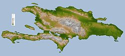
    • hispaniola is an island in the west indies caribbean sea that contains two separate countries name the two countries
    • hispaniola flag in 1513
    • hispaniola flag in
    • hispaniola plants


Not Finding Your Answer?
Post It On KidzTalk Homework Help


   Report a search problem


COMPANY RESOURCES LINKS SOCIAL
contact us education daily journal home facebook
about us make us your default search kidztalk twitter  
terms/privacy blocking websites kidznet pinterest  
advertise teacher zone wiki    
media link to us learning sites    
business / api solutions add a site image search    
affiliate program kidzsearch apps kidztube    
play youtube on kidzsearch games    
  voice search music    
  report a problem cool facts    
  settings news    
    search help    


 mobile version

      Copyright 2005-2024 KidzSearch.com 
Hispaniola
Topographic map of Hispaniola
Geography
LocationCaribbean Sea
ArchipelagoAntilles
Area76,480 km2 (29,529 sq mi)
Highest pointPico Duarte (3,087 m)
Countries
  Haiti
PresidentJovenel Moise
Capital cityPort-au-Prince (1,900,000)
  Dominican Republic
PresidentLuis Abinader
Capital citySanto Domingo (913,540)
(Metro: 2,253,437)
Demographics
Population20,113,564 (as of July 2013)
Density263

Hispaniola is an island in the Caribbean Sea. It is the second largest island (after Cuba) of the West Indies, east of Cuba and west of Puerto Rico.

The Republic of Haiti occupies the western three-eighths, the Dominican Republic the rest. Hispaniola is one of two Caribbean islands in which there are two countries; the other is Saint Martin.

 view more...