

Not Finding Your Answer?
Post It On KidzTalk Homework Help
Post It On KidzTalk Homework Help
Report a search problem

|
mobile version
Copyright 2005-2024 KidzSearch.com
|
|
 | |
 Flag  Coat of arms | |
Location of Eschweiler within Aachen district | |
| Coordinates: 50°49′N 6°17′E / 50.817°N 6.283°ECoordinates: 50°49′N 6°17′E / 50.817°N 6.283°E | |
| Country | Germany |
| State | North Rhine-Westphalia |
| Admin. region | Cologne |
| District | Aachen |
| Subdivisions | 22 |
| Government | |
| • Mayor | Rudi Bertram (SPD) |
| Area | |
| • Total | 76.559 km2 (29.560 sq mi) |
| Highest elevation | 262 m (860 ft) |
| Lowest elevation | 110 m (360 ft) |
| Population (2006-12-31) | |
| • Total | 55,171 |
| • Density | 720.634/km2 (1,866.433/sq mi) |
| Time zone | UTC+01:00 (CET) |
| • Summer (DST) | UTC+02:00 (CEST) |
| Postal codes | 52249 |
| Vehicle registration | AC, MON |
| Website | www |
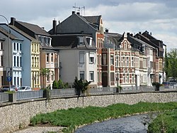
Eschweiler is a German town in the state of North Rhine-Westphalia. It is next to the river Inde, near the German-Belgian-Dutch frontier, and about 15 kilometres (9.3 miles) east of Aachen and 50 kilometres (31.1 miles) west of Cologne. It has about 55,000 inhabitants. Its area has about 77 square kilometres (29.7 square miles).
