
|
  | |
 | |
| Geography | |
| Status | Ceremonial & (smaller) Non-metropolitan county |
|---|---|
| Region: | South West England |
| Area - Total - Admin. council - Admin. area | Ranked 14th 2,165 miles² (3,485 km²) Ranked 13th 2,022 miles² (3,255 km²) |
| Admin HQ: | Trowbridge |
| ISO 3166-2: | GB-WIL |
| ONS code: | 46 |
| NUTS 3: | UKK15 |
| Demographics | |
| Population - Total (2005 est.) - Density - Admin. council - Admin. pop. | Ranked 34th 630,700 181 / km² Ranked 30th 446,700 |
| Ethnicity: | 97.5% White |
| Politics | |
| Wiltshire County Council http://www.wiltshire.gov.uk/ | |
| Executive | Conservative |
| Members of Parliament | |
| Districts | |
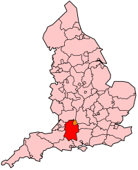
Wiltshire (short: Wilts) is an English county. It borders the counties of Hampshire, Dorset, Somerset, Gloucestershire, Oxfordshire and Berkshire, and contains the unitary authority of Swindon. The county town is Trowbridge, in the west of the county at . The county covers 858,931 acres (3476 km²)
view more...

|