KidzSearch Image Safe Search   


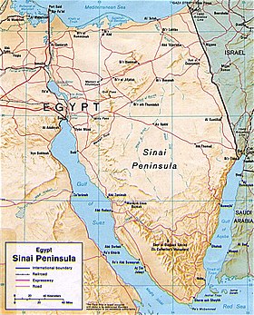
Map of the Sinai Peninsula with country borders shown

The Sinai Peninsula or Sinai (Arabic: سيناء Sīnā), is a triangular peninsula in Egypt. It is about 60,000 km2 (23,000 sq mi) in area. It is between the Mediterranean Sea to the north and the Red Sea to the south. It is the only part of Egyptian territory located in Asia. This is because the Sinai is known as a land bridge between the two continents of Africa and Asia. There are approximately 500,000 people living there. Egyptians refer to it as the "Land of Fayrouz", based on the Ancient Egyptian "Dumafkat".

Sinai desert
 view more...


   Related Content
    • sinai peninsula
    • sinai rose lol
    • sinai peninsula facts
    • sinai agama
    • sinai liberation day
    • sinai peninsula photos
    • sinai egypt
    • sinai desert
    • sinai peninsula animals
    • sinai liberation day celebration


Not Finding Your Answer?
Post It On KidzTalk Homework Help


   Report a search problem


COMPANY RESOURCES LINKS SOCIAL
contact us education daily journal home facebook
about us make us your default search kidztalk twitter  
terms/privacy blocking websites kidznet pinterest  
advertise teacher zone wiki    
media link to us learning sites    
business / api solutions add a site image search    
affiliate program kidzsearch apps kidztube    
play youtube on kidzsearch games    
  voice search music    
  report a problem cool facts    
  settings news    
    search help    


 mobile version

      Copyright 2005-2024 KidzSearch.com