
|
| དེན་ཇོནྒ | |
|---|---|
 | |
 Seal | |
 Location of Sikkim in India | |
 Map of Sikkim | |
| Coordinates: 27°33′N 88°30′E / 27.550°N 88.500°ECoordinates: 27°33′N 88°30′E / 27.550°N 88.500°E | |
| Country | |
| Region | North-east India |
| Established | 16 May 1975 |
| Government | |
| • Legislature | Unicameral (seats) |
| Area | |
| • Total | 7,110 km2 (2,750 sq mi) |
| Population (2011) | |
| • Total | 610,577 |
| Time zone | UTC+05:30 (IST) |
| Official languages | Nepali (lingua franca) English Bhutia and Lepcha (since 1977) Limbu (since 1981) Newari, Gurung, Magar, Sherpa, and Tamang (since 1995) Sunwar (since 1996) |
| ^National Anthem of Sikkim | |
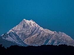
Sikkim (Hindi: सिक्किम) has been a state in India since 1975. It has the smallest number of people and second smallest land size (7,110 square kilometres or 2,750 sq mi) of any major divisions in the Republic of India. The third highest mountain in the world, Mt. Kanchenjunga (8,597 metres or 28,205 ft above sea level), is in Sikkim. Its neighbours are Bhutan to the east, Nepal to the west, the Tibet Autonomous Region of P.R.C. to the north and the Indian province of West Bengal to its south. The state capital is Gangtok and other big towns are Gayzing, Pelling, Yuksam and Jorethang. The languages spoken here are Sikkimese, Lepcha, Tibetan, Nepali, Hindi and English. Tourism makes a lot of the money in this small organised state of India, because it is not close to the sea.


|