KidzSearch Image Safe Search   


A satellite image of the Sahara.
Sand dunes in the Sahara desert

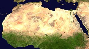
The Sahara, in North Africa, is the largest desert in the world except for Antarctica. The Sahara is the largest hot desert.

It is bounded by the Atlantic Ocean, the Atlas Mountains, the Mediterranean Sea, the Red Sea, and the Sahel region. It runs through many countries including Morocco, Algeria, Tunisia, Libya, Egypt, Mauritania, Mali, Niger, Chad, and The Sudan. Most parts are uninhabited, but some people manage to survive in places where there is water.

 view more...


   Related Content
    • sahara desert
    • sahara desert animals
    • sahara desert plants
    • sahara desert facts
    • sahara desert facts for kids
    • sahara desert map
    • sahara dessert
    • sahara pump theory
    • sahara desert climate
    • sahara desert location


Not Finding Your Answer?
Post It On KidzTalk Homework Help


   Report a search problem


COMPANY RESOURCES LINKS SOCIAL
contact us education daily journal home facebook
about us make us your default search kidztalk twitter  
terms/privacy blocking websites kidznet pinterest  
advertise teacher zone wiki    
media link to us learning sites    
business / api solutions add a site image search    
affiliate program kidzsearch apps kidztube    
play youtube on kidzsearch games    
  voice search music    
  report a problem cool facts    
  settings news    
    search help    


 mobile version

      Copyright 2005-2024 KidzSearch.com