
|
| Overijssel / Oaveriessel | |
|---|---|
Province | |
 | |
 Flag  Coat of arms | |
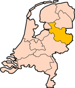  Location | |
 Map | |
| Coordinates: 52°27′N 6°27′E / 52.450°N 6.450°E | |
| Country | Netherlands |
| Established | 1815 |
| Seat | Zwolle |
| Area | |
| • Total | 3,421 km2 (1,321 sq mi) |
| • Land | 3,319 km2 (1,281 sq mi) |
| • Water | 102 km2 (39 sq mi) |
| Highest elevation | 85 m (279 ft) |
| Lowest elevation | -2 m (−6.6 ft) |
| Population (2021) | |
| • Total | 1,166,000 |
| • Density | 351/km2 (910/sq mi) |
| Website | www |
Overijssel (Latin: Transisalania) is a province of the Netherlands. It is in the central eastern part of the country. The province's name in both Dutch and Latin means "Lands across river IJssel". The capital city of Overijssel is Zwolle. Its biggest city is Enschede. About 1,166,000 people are living in Overijssel (2021).
view more...

|