|
 Coat of arms | |
Location of Lostorf Lua error in Module:Infobox_mapframe at line 118: attempt to index field 'wikibase' (a nil value). | |
| Coordinates: 47°23′N 7°57′E / 47.383°N 7.950°ECoordinates: 47°23′N 7°57′E / 47.383°N 7.950°E | |
| Country | Switzerland |
| Canton | Solothurn |
| District | Gösgen |
| Area | |
| • Total | 13.27 km2 (5.12 sq mi) |
| Elevation | 451 m (1,480 ft) |
| Population (December 2005) | |
| • Total | 3,636 |
| • Density | 274.00/km2 (709.7/sq mi) |
| Time zone | UTC+01:00 (Central European Time) |
| • Summer (DST) | UTC+02:00 (Central European Summer Time) |
| Postal code(s) | 4654 |
| Surrounded by | Niedergösgen, Obergösgen, Rohr, Stüsslingen, Trimbach, Winznau, Wisen, Zeglingen (BL) |
| Twin towns | Rielasingen (Germany) |
| Website | www SFSO statistics |
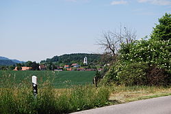
Lostorf is a municipality in the district Gösgen in the canton of Solothurn in Switzerland.
view more...

|