|
 | |
 Coat of arms | |
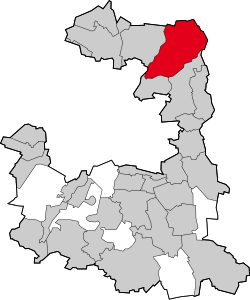
Location of Ismaning within Munich district | |
| Coordinates: 48°13′35″N 11°40′21″E / 48.22639°N 11.67250°ECoordinates: 48°13′35″N 11°40′21″E / 48.22639°N 11.67250°E | |
| Country | Germany |
| State | Bavaria |
| Admin. region | Oberbayern |
| District | Munich |
| Government | |
| • Mayor | Alexander Greulich (SPD) |
| Area | |
| • Total | 40.19 km2 (15.52 sq mi) |
| Elevation | 490 m (1,610 ft) |
| Population | |
| • Total | 16,770 |
| • Density | 417.27/km2 (1,080.7/sq mi) |
| Time zone | UTC+01:00 (CET) |
| • Summer (DST) | UTC+02:00 (CEST) |
| Postal codes | 85737 |
| Vehicle registration | M |
| Website | ismaning |
Ismaning is a municipality in the Munich Rural District in Upper Bavaria, Germany. As of December 31, 2008, it had a population of 15,181. view more...


|