KidzSearch Image Safe Search   


Province
20170823 001 tm 005 Lelystad Oostvaardersplassen (36385481070).jpg
Flag of Flevoland
Coat of arms of Flevoland
Map: Province of Flevoland in the NetherlandsSouth HollandNorth HollandFrieslandGroningenDrentheFlevolandOverijsselGelderlandUtrechtLimburgNorth BrabantZeeland (province)
About this image
Location
Map
Map
Coordinates: 52°32′N 5°40′E / 52.533°N 5.667°E / 52.533; 5.667
CountryNetherlands
Established1986
SeatLelystad
Area
 • Total2,412 km2 (931 sq mi)
 • Land1,412 km2 (545 sq mi)
 • Water1,001 km2 (386 sq mi)
Highest elevation
8 m (26 ft)
Lowest elevation
-5 m (−16.4 ft)
Population
 (2021)
 • Total428,000
 • Density303/km2 (780/sq mi)
Websitewww.flevoland.nl

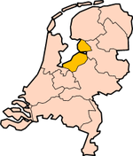
Flevoland is one of the provinces of the Netherlands. Lelystad is its capital, but Almere is its biggest city. About 428,000 people are living in Flevoland (2021).

Location of the municipalities of Flevoland.

  1. Almere
  2. Dronten
  3. Lelystad
  4. Noordoostpolder
  5. Urk
  6. Zeewolde

GemeentenFlevolandNrs.png

 view more...


Not Finding Your Answer?
Post It On KidzTalk Homework Help


   Report a search problem


COMPANY RESOURCES LINKS SOCIAL
contact us education daily journal home facebook
about us make us your default search kidztalk twitter  
terms/privacy blocking websites kidznet pinterest  
advertise teacher zone wiki    
media link to us learning sites    
business / api solutions add a site image search    
affiliate program kidzsearch apps kidztube    
play youtube on kidzsearch games    
  voice search music    
  report a problem cool facts    
  settings news    
    search help    


 mobile version

      Copyright 2005-2024 KidzSearch.com