|
 Coat of arms | |
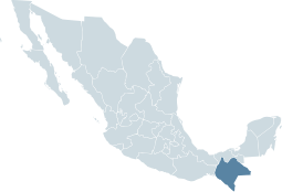 Location within Mexico | |
| Coordinates: 16°24′36″N 92°24′31″W / 16.4100°N 92.4086°WCoordinates: 16°24′36″N 92°24′31″W / 16.4100°N 92.4086°W | |
| Country | Mexico |
| Capital | Tuxtla Gutiérrez |
| Municipalities | 118 |
| Largest City | Tuxtla Gutiérrez |
| Government | |
| • Governor | Juan José Sabines Guerrero (PRD) |
| • Federal Deputies | PRI: 7 PRD: 5 |
| • Federal Senators | PRI: 1 PRD: 1 PVEM: 1 |
| Area | |
| • Total | 74,211 km2 (28,653 sq mi) |
| Population (2005) | |
| • Total | 4,293,459(Ranked 7th) |
| HDI (2004) | 0.7076 - medium Ranked 32nd |
| ISO 3166-2 | MX-CHP |
| Postal abbr. | Chis. |
| Website | Chiapas State Government |
Chiapas is the southernmost state of Mexico. It is towards the southeast of the country. Chiapas is bordered by the states of Tabasco to the north, Veracruz to the northwest, and Oaxaca to the west. To the east Chiapas borders Guatemala, and to the south the Pacific Ocean.
Chiapas has an area of 28,528 square miles (73,890 km2). The 2005 census population was 4,293,459 people.


|