
|
| Bedfordshire | |
|---|---|
 | |
| Geography | |
| Status | Ceremonial & (smaller) Non-metropolitan county |
| Region | East of England |
| Area - Total - Admin. council - Admin. area | Ranked 41st 1,235 km2 (477 sq mi) Ranked 34th 1,192 km2 (460 sq mi) |
| Admin HQ | Bedford |
| ISO 3166-2 | GB-BDF |
| ONS code | 09 |
| NUTS 3 | UKH22 |
| Demography | |
| Population - Total (2005 est.) - Density - Admin. council - Admin. pop. | Ranked 36th 582,600 472/km2 (1,220/sq mi) Ranked 32nd 397,700 |
| Ethnicity | 86.3% White 8.3% S.Asian 2.9% Afro-Carib. |
| Politics | |
| Bedfordshire County Council http://www.bedfordshire.gov.uk/ | |
| Executive | Conservative |
| Members of Parliament | |
| Districts | |
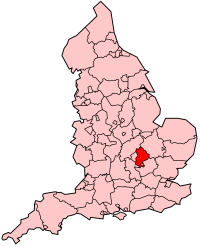
Bedfordshire is a county of England. Its county town is Bedford. It borders Cambridgeshire, Northamptonshire, Buckinghamshire (with the Borough of Milton Keynes) and Hertfordshire. The highest elevation point is 243 m (797 ft) on Dunstable Downs in the Chilterns. The county motto is "Constant Be", which is taken from the hymn To Be A Pilgrim by John Bunyan. view more...


|