|
| Ballarat Victoria | |||||||||
|---|---|---|---|---|---|---|---|---|---|
| |||||||||
| Lua error in Module:Infobox_mapframe at line 118: attempt to index field 'wikibase' (a nil value). | |||||||||
| Coordinates | 37°33′0″S 143°51′0″E / 37.55000°S 143.85000°ECoordinates: 37°33′0″S 143°51′0″E / 37.55000°S 143.85000°E | ||||||||
| Population | 101,588 (2016) (17th) | ||||||||
| • Density | 295.66/km2 (765.8/sq mi) | ||||||||
| Established | 1838 | ||||||||
| Postcode(s) | 3350 | ||||||||
| Elevation | 435 m (1,427 ft) AHD | ||||||||
| Area | 343.6 km2 (132.7 sq mi) (2016 census – SUA) | ||||||||
| Time zone | AEST (UTC+10) | ||||||||
| • Summer (DST) | AEDT (UTC+11) | ||||||||
| Location | |||||||||
| LGA(s) | City of Ballarat | ||||||||
| State electorate(s) | |||||||||
| Federal division(s) | Ballarat | ||||||||
| |||||||||
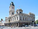
Ballarat is a city in central Victoria, Australia. Nearly 90,200 people live there, which makes it the third biggest city in Victoria, after Melbourne and Geelong. It is also the biggest city that is not on the coast in Victoria. It is about 105 km (65 mi) north-west of Melbourne. The city area covers about 7,500 ha (18,533 acres).
view more...

|