
|
 | |
 Flag  Coat of arms | |
Location of Goslar within Goslar district | |
| Coordinates: 51°54′26″N 10°25′48″E / 51.90722°N 10.43000°ECoordinates: 51°54′26″N 10°25′48″E / 51.90722°N 10.43000°E | |
| Country | Germany |
| State | Lower Saxony |
| District | Goslar |
| Subdivisions | 18 districts |
| Government | |
| • Lord mayor | Dr Oliver Junk (CDU) |
| Area | |
| • Total | 163.71 km2 (63.21 sq mi) |
| Elevation | 255 m (837 ft) |
| Time zone | UTC+01:00 (CET) |
| • Summer (DST) | UTC+02:00 (CEST) |
| Postal codes | 38640, 38642, 38644 |
| Vehicle registration | GS |
| Website | www |
| UNESCO World Heritage Site | |
|---|---|
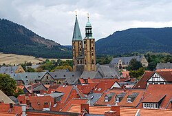
 View to the North with the Hildesheim downs in the background. Photograph taken from the Maltermeister Tower | |
| Part of | Mines of Rammelsberg, Historic Town of Goslar and Upper Harz Water Management System |
| Criteria | Cultural: i, iv |
| Reference | 623-001 |
| Inscription | 1992 (16th Session) |
| Extensions | 2010 |
| Area | 363.3 ha |
| Buffer zone | 376.1 ha |
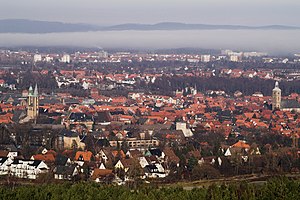
Goslar is a historic city in Germany. About 43,000 people live there.
view more...

|
