KidzSearch Image Safe Search   


Dubois County, Indiana
Map
Map of Indiana highlighting Dubois County
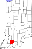
Location in the state of Indiana
Map of the USA highlighting Indiana
Indiana's location in the U.S.
Statistics
FoundedDecember 20, 1818
SeatJasper
Largest CityJasper
Area
 - Total
 - Land
 - Water

435.33 sq mi (1,127 km²)
427.27 sq mi (1,107 km²)
8.06 sq mi (21 km²), 1.85%
Population
 - (2020)
 - Density

43,637
97.4/sq mi (38/km²)
Time zoneEastern: UTC-5/-4
Named for: Toussaint Dubois
Indiana county number 19

Dubois County is a county in the U.S. state of Indiana. As of 2020, 43,637 people lived there. The county seat is Jasper. view more...


   Related Content
    • w e b dubois biography


Not Finding Your Answer?
Post It On KidzTalk Homework Help


   Report a search problem


COMPANY RESOURCES LINKS SOCIAL
contact us education daily journal home facebook
about us make us your default search kidztalk twitter  
terms/privacy blocking websites kidznet pinterest  
advertise teacher zone wiki    
media link to us learning sites    
business / api solutions add a site image search    
affiliate program kidzsearch apps kidztube    
play youtube on kidzsearch games    
  voice search music    
  report a problem cool facts    
  settings news    
    search help    


 mobile version

      Copyright 2005-2024 KidzSearch.com