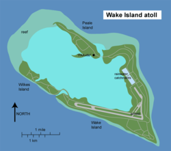
KidzSearch Image Safe Search   


Wake Island
Wake Island map.png
Map of Wake Island
Geography
LocationNorth Pacific
Coordinates19°18′N 166°38′E / 19.300°N 166.633°E / 19.300; 166.633Coordinates: 19°18′N 166°38′E / 19.300°N 166.633°E / 19.300; 166.633
Total islands3
Area2.85 sq mi (7.4 km2)
Coastline12.0 mi (19.3 km)
Elevation20 ft (6.1 m)
Highest pointDucks Point
Country
 United States
Wake Island is under the administration of the United States Air Force
Demographics
Population0 permanent, 100 temporary
Aerial overview of the atoll

Wake Island is an atoll (a type of island) in the Pacific Ocean, near Hawaii. It is controlled by the United States Army and United States Air Force. It is a territory of the United States, part of the United States Minor Outlying Islands. From December 1941 to August 1945 the Empire of Japan ruled Wake Island.

 view more...


   Related Content
    • wake island war
    • wake island holidays
    • wake island flag
    • wake island ww2


Not Finding Your Answer?
Post It On KidzTalk Homework Help


   Report a search problem


COMPANY RESOURCES LINKS SOCIAL
contact us education daily journal home facebook
about us make us your default search kidztalk twitter  
terms/privacy blocking websites kidznet pinterest  
advertise teacher zone wiki    
media link to us learning sites    
business / api solutions add a site image search    
affiliate program kidzsearch apps kidztube    
play youtube on kidzsearch games    
  voice search music    
  report a problem cool facts    
  settings news    
    search help    


 mobile version

      Copyright 2005-2024 KidzSearch.com