KidzSearch Image Safe Search   


Coordinates: 51°29′52″N 0°02′12″E / 51.497744°N 0.036679°E / 51.497744; 0.036679

River Thames Flood Barrier
The gate in the middle of this view has been raised to the maintenance position; a barge can be seen in the foreground.

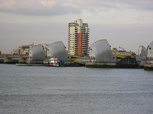
The Thames Barrier is the world's second-largest movable flood barrier, after the Oosterscheldekering in the Netherlands. It is downstream of central London. Its purpose is to prevent London from being flooded by exceptionally high tides and storm surges moving up from the North Sea. It is raised (closed) only during high tide; at ebb tide it is lowered to release the water which backs up behind it.

 view more...


Not Finding Your Answer?
Post It On KidzTalk Homework Help


   Report a search problem


COMPANY RESOURCES LINKS SOCIAL
contact us education daily journal home facebook
about us make us your default search kidztalk twitter  
terms/privacy blocking websites kidznet pinterest  
advertise teacher zone wiki    
media link to us learning sites    
business / api solutions add a site image search    
affiliate program kidzsearch apps kidztube    
play youtube on kidzsearch games    
  voice search music    
  report a problem cool facts    
  settings news    
    search help    


 mobile version

      Copyright 2005-2024 KidzSearch.com