KidzSearch Image Safe Search   


Satellite image of the Bering Strait.

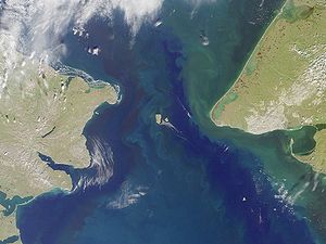
The Bering Strait (Russian: Берингов пролив) is a sea strait between Cape Dezhnev, Russia, the easternmost point (169°43' W) of the Asian continent and Cape Prince of Wales on the edge of the Seward Peninsula, Alaska, the westernmost point (168°05' W) of the North American continent, with latitude of about 65° 40' north, slightly south of the Arctic Circle. The strait was made around 40,000 years ago, when an old landmass between Asia and America known as Beringia was flooded at the end of the last ice age. The strait is passed through by the international date line, making from the view of the Russian side from the Alaskan side like looking at tomorrow.

 view more...


Not Finding Your Answer?
Post It On KidzTalk Homework Help


   Report a search problem


COMPANY RESOURCES LINKS SOCIAL
contact us education daily journal home facebook
about us make us your default search kidztalk twitter  
terms/privacy blocking websites kidznet pinterest  
advertise teacher zone wiki    
media link to us learning sites    
business / api solutions add a site image search    
affiliate program kidzsearch apps kidztube    
play youtube on kidzsearch games    
  voice search music    
  report a problem cool facts    
  settings news    
    search help    


 mobile version

      Copyright 2005-2024 KidzSearch.com