KidzSearch Image Safe Search   


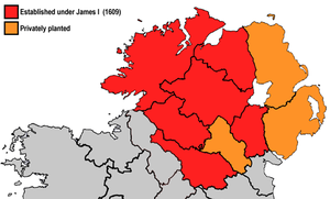
The counties of Ulster (modern boundaries) that were colonised during the plantations. This map is a simplified one, as the amount of land actually colonised did not cover the entire shaded area.

The Plantation of Ulster was the organised colonisation (plantation) of Ulster. Ulster is a province of Ireland. People from Scotland and England were sent by the English government to live there. This started at the beginning of the 17th century, from 1606. It was colonised to stop the people living in the area fighting against the English rule. Ulster had been the region most resistant to English control during the previous century.

 view more...


Not Finding Your Answer?
Post It On KidzTalk Homework Help


   Report a search problem


COMPANY RESOURCES LINKS SOCIAL
contact us education daily journal home facebook
about us make us your default search kidztalk twitter  
terms/privacy blocking websites kidznet pinterest  
advertise teacher zone wiki    
media link to us learning sites    
business / api solutions add a site image search    
affiliate program kidzsearch apps kidztube    
play youtube on kidzsearch games    
  voice search music    
  report a problem cool facts    
  settings news    
    search help    


 mobile version

      Copyright 2005-2024 KidzSearch.com