
Not Finding Your Answer?
Post It On KidzTalk Homework Help
Post It On KidzTalk Homework Help
Report a search problem

|
mobile version
Copyright 2005-2024 KidzSearch.com
|
|
| Estado Libre y Soberano de Veracruz de Ignacio de la Llave | |
|---|---|
 Flag  Coat of arms | |
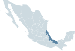 Location within Mexico | |
| Coordinates: 19°11′N 96°08′W / 19.19°N 96.14°WCoordinates: 19°11′N 96°08′W / 19.19°N 96.14°W | |
| Country | |
| Capital | Xalapa |
| Municipalities | 212 |
| Largest City | Veracruz |
| Government | |
| • Governor | Cuitláhuac García Jiménez (MORENA) |
| • Federal Deputies | MORENA: 6 PAN: 11 PRD: 2 Convergencia: 2 |
| • Federal Senators | PRD: 1 PAN: 1 Convergencia: 1 |
| Area | |
| • Total | 71,699 km2 (27,683 sq mi) |
| Population (2005) | |
| • Total | 7,110,214 (Ranked 3rd) |
| Time zone | UTC-6 (CST) |
| • Summer (DST) | UTC-5 (CDT) |
| HDI (2004) | 0.7457 - medium Ranked 28th |
| ISO 3166-2 | MX-VER |
| Postal abbr. | Ver. |
Veracruz is one of the 32 states of Mexico. view more...