Coat of arms
Etymology: Old English Beormingahām (home or settlement of the Beormingas
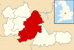
Coordinates: 52°28′59″N 1°53′37″W / 52.48306°N 1.89361°W / 52.48306; -1.89361 Coordinates : 52°28′59″N 1°53′37″W / 52.48306°N 1.89361°W / 52.48306; -1.89361 Sovereign state United Kingdom Constituent country England Region West Midlands Ceremonial county West Midlands Historic county Warwickshire Settlement c. 600 Seigneurial borough 1166 Municipal borough 1838 City status 14 January 1889 Metropolitan borough 1 April 1974 Administrative HQ The Council House ,Victoria Square • Type Metropolitan borough • Body Birmingham City Council • Leadership Leader and cabinet • Executive • Leader Vacant (Deputy Leader Ian Ward, acting) • Lord Mayor Anne Underwood • Chief Executive (Interim) Stella Manzie CBE • City 103.4 sq mi (267.8 km2 ) • Urban
231.2 sq mi (598.9 km2 ) • Rank 151st Elevation
460 ft (140 m) • Rank 1st • Urban
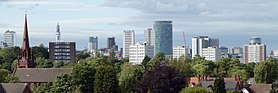
2,440,986 (3rd ) • Metro
4,332,629 (List of metropolitan areas in Europe ) Time zone UTC+0 (Greenwich Mean Time ) • Summer (DST ) UTC+1 (British Summer Time )Postcode ISO 3166 code GB-BIR GSS codeE08000025 NUTS 3 code UKG31 ONS code 00CN OS grid reference Script error: No such module "Ordnance Survey coordinates". Motorways M6 M6 Toll M5 M42 A38(M) Ethnicity(2011 Census) 57.9% White (53.1% White British) 26.6% Asian 8.9% Black 4.4% Mixed Race 2.0% Other International airports Birmingham (BHX )Major railway stations Birmingham New Street (A )Birmingham Moor Street (B )Birmingham Snow Hill (C1 )GDP US$ 121.1 billion2nd )– Per capita US$ 31,572Councillors 120 MPs Website www.birmingham.gov.uk